Ryknild Street (Ryknild is as on the OS mop but also known as Ryknield, Rykeneld Street or Ryknield Street) originally came from Wall (Letocetum) near Lichfield into Little Chester also known as Chester Green after the area of open parkland at its centre, a suburb of Derby, Located approximately 0.6 miles (0.97 km) north of the city centre, on the east bank of the River Derwent.
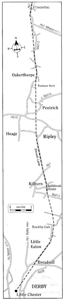
Map of section of Ryknield Street Roman road
It forms part of the Darley Ward along with Darley Abbey and the West End. Little Chester is the oldest inhabited part of Derby, having been the location of a fortified Roman settlement called Derventio. Its line is followed very closely by the modern A38. As the legions pushed further north, they extended Ryknield Street through Chesterfield to Templeborough.
The route from Little Chester seems to have been through Breadsall; the line is through the fields somewhat to the east of the present road leading to Brackley Gate where there was a change in direction to very nearly due north. Excavations have shown that the rood was about 18 ft wide. The line of the road can be seen in the fields and then on Street Lane (a name confirming that this is the line of the Roman strata) and this goes through the hamlet of Street Lane just North of Kilburn and on as for as a point just short of its junction with the Heoge to Ripley road.
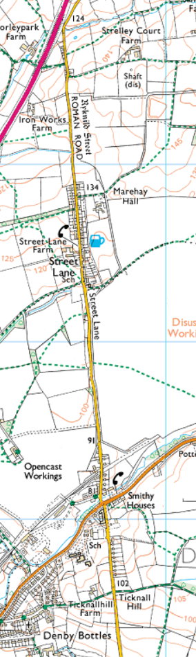
Street Lane on Ryknield Street
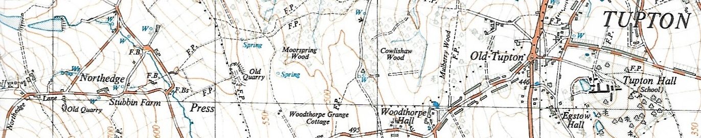
Here was another small change in direction to a line that brought the road a little to the west of the village of Pentrich and close to, but not actually through, the small Roman fort there. This minor fort must have been thrown up by the Romans at an early date and abandoned before this northern extension of Ryknild Street was constructed. The Roman rood joins 86013 just short of Oakerthorpe. From there the present road through Clay Cross to Chesterfield follows Ryknild Street fairly closely. The village of Stretton was named from its location on this Street. Beyond Clay Cross, where the A61 begins to veer slightly to the West at Hilltop form, the Roman rood continued due North past Egstow Hall to New Tupton. From there to Mill Lane, Wingerworth and under the former Avenue Carbonisation Plant. A Roman site has been confirmed at Chesterfield by excavation. ref 4,9
The line of Ryknield Street was noted by Doctor Samuel Pegge, a Chesterfield antiquarian (1704-1796).
‘Hence along the line of the present turnpike road to Clay Cross, through the village of Stretton; then to Egstow (where there is a large barrow) and is quite plain for some three hundred yards through some small enclosures (particularly in the Quakers’ Burying ground) and over a part of Tupton Moor, near to the Blacksmith’s forge; and in an old survey of Egstow Farm, belonging to the Hunloke Family, it is expressly described under the name of the Rignal Street.” This quotation is from Glover’s History of Derbyshire, 1829, but the greater part of it was written by Pegge many years before.
Traces of the road are very few today. The former Quaker Burial Ground (the field adjoining the large stone house near the Tupton Hall Grammar School gates) has a ridge running from north to south, and traces of the road have been found in nearby gardens. Excavations made a few hundred yards south of this point a few years ago revealed the road under a few inches of turf. The barrow at Egstow Farm mentioned by Glover was also opened by means of a trial trench, but turned out to be a rubbish tip roughly contemporary with the farm itself (1671). ref 6
A letter from John Grattan of Wingerworth to Stephen Glover is worthy of note :— ‘Wingerworth, May 25th, 1829, I have paid considerable attention to the Roman Rood in the parish of Wingerworth as I have travelled about.
This morning, I walked across the fields the line, or the supposed line, of the Roman Rood, from Clay Cross to Chesterfield. For the first half-mile, until I came to an occupation lane, half a mile before I got to Egstow Hall, I found little, if any, remains of the rood, the ground having been much cultivated and broken up by getting coal and ironstone in this part. Having entered the said lane, it was quite visible far two miles, by Egstow Hall, and Tupton, until I got to the lane leading from Wingerworth to the Mill, called Mill Lane ; after this I cannot say that I decidedly found any more traces of it.
I had several opportunities of seeing how the rood was made, at places where the farmers had cut ditches across it, and it seems to be formed merely of such rubble stone and sharp gravel as was nearest at hand”
Archaeological work has been undertaken on Ryknild Street.