Ryknild Street North East of Pear Tree farm from Historic England –
Section of Ryknield Street Roman road 220m north east of Pear Tree Farm is classed as a monument scheduled under the Ancient Monuments and Archaeological Areas Act 1979
List entry Number: 1021444
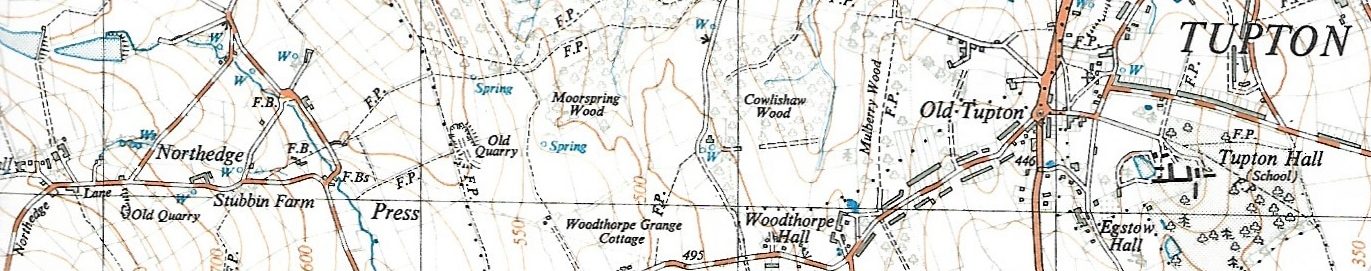
This monument includes a section of Ryknield Street Roman road, here visible as an earthwork, forming part of the original Roman road between Chesterfield and Little Chester. This is a proven Roman road serving Chesterfield and Pentrich Roman forts traceable for many miles to the north and south of the site. The earthwork survives well in two sections and the monument is therefore defined by two separate areas of protection. These two areas of Ryknield Street have been identified as the best preserved section of the Roman road certainly within the county of Derbyshire if not further afield. At Old Tupton the road is broadly aligned north-northeast by south-southwest, angling eastwards towards Eckington as it continues northwards of the site. The northernmost section survives as a substantial earthwork approximately 105m in length and 1-1.5m in height and rises to a cambered surface. The western limit of the earthwork has been obscured through a raising and levelling of the ground to the west of the monument that might relate to the use of the site as a cricket pitch in the early C20. The southern area of protection is more denuded standing approximately 0.3m high. It is approximately 30m in length, the southernmost 10m of the earthwork having been truncated, possibly at the time Egstow Hall (a Grade II listed building) was built in the C17. The earthwork does not survive above ground immediately beyond this section. Investigation beneath the peak of the camber to the west of Packman’s Cottages revealed a stony or hard substrate at a depth of 10-20cm which is understood to be the road surface. A second partial excavation found 5cm by 5cm pieces of sandstone at a depth of 20-25cm. These findings are comparable to the construction material discovered during excavation of a section of the road to the north in New Tupton in May 1975. Here at least two phases of road surfaces were revealed. All hardstandings, fence posts, boundary markers, the roofed structure located in the south west corner of the southern area of protection and the gate and gate posts are excluded from the scheduling, but the ground beneath all these features is included. At Old Tupton the road is broadly aligned north-northeast by south-southwest, angling eastwards towards Eckington as it continues northwards of the site. The northern-most section survives as a substantial earthwork approximately 105m in length and 1-1.5m in height and rises to a cambered surface. The western limit of the earthwork has been obscured through a raising and levelling of the ground to the west of the monument that might relate to the use of the site as a cricket pitch in the early C20. The southern section of the monument is more denuded standing approximately 0.3m high. It is approximately 30m in length, the southern most 10m of the earthwork having been truncated, possibly at the time Egstow Hall (Grade II) was built in the C17. The earthwork does not survive above ground immediately beyond this section. Investigation beneath the peak of the camber to the west of Packman’s Cottages revealed a stony or hard substrate at a depth of 10-20cm which is understood to be the road surface. A second partial excavation found five by 5cm pieces of sandstone at a depth of 20-25cm. These findings are comparable to the construction material discovered during excavation of a section of the road to the north in New Tupton in May 1975. Here at least two phases of road surfaces were revealed. All hardstandings, fence posts, boundary markers, the roofed structure located in the south west corner of the southern area of protection and the gate and gate posts are excluded from the scheduling but the ground beneath all these features is included.
National Grid Reference: SK 39084 65044, SK 39095 65207